Home
Research
People
Openings
Contact
Light
Dark
Automatic
Current-researches
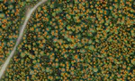
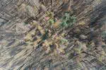
Drone-based forest mapping
Developing methods to map forests at the individual tree level using drones, photogrammetry, and computer vision
Derek Young
,
David Russell
,
Amritha Pallavoor
Automated understory fuel inventory
Using 360-degree ground imagery for automated understory vegetation and fuel inventory
Derek Young
,
David Russell
,
Amritha Pallavoor
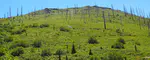
Long-term post-fire forest recovery
Using aerial imagery and computer vision to quantify forest recovery 10-40 years post-fire across California
Derek Young
,
David Russell
,
Amritha Pallavoor
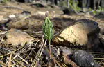
Early post-fire regeneration
Understanding the early (1-2 years post-fire) drivers of conifer regeneration in high-severity burn patches
Tessa Putz
,
Derek Young
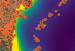
Mapping post-fire surviving trees
Using high-resolution satellite imagery and plot data to build tools for rapid mapping of surviving trees following fire
Saba Saberi
Post-fire conifer seed dispersal
Combining drone-based tree maps and field surveys to model seed dispersal and tree regeneration across post-fire landscapes
Derek Young
,
Andrew Latimer