Mapping post-fire surviving trees
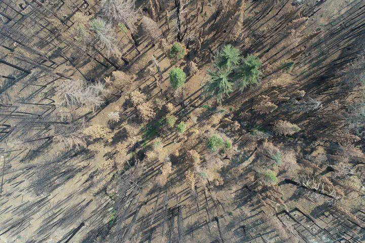
Wildfires in western U.S. dry forests are increasingly burning large areas at high severity. In large contiguous severely burned patches, near-complete overstory mortality challenges natural forest regeneration processes, which require nearby surviving trees to serve as seed sources. Evaluating burn severity patterns – and thus regeneration potential – across large wildfires generally relies on satellite imagery due to its ready availability and spatially continuous coverage. However, the imagery datasets traditionally used have relatively coarse pixels (e.g., ~ 30 m for Landsat), which can contain multiple trees and may miss small patches of surviving trees (“fire refugia”) that have critical value as seed sources for regeneration. In addition, traditional approaches for evaluating post-fire condition rely on satellite derived burn severity metrics, which quantify the amount of vegetation loss due to fire, but they do not directly quantify the presence or absence of residual live trees, which is likely the more important factor for predicting regeneration potential.
Trees that initially survive the fire – but that sustained injuries – may ultimately die in the following years, with implications for their value as seed sources. The presence of drought before and/or after fire may affect the prevalence of fire refugia and delayed mortality.
We have developed models that use higher-resolution imagery data sources (e.g. Sentinel-2) to understand the prevalence and spectral signatures of small fire refugia and have published this work. The work, which focused on recent large wildfires in California, also involved tailored collection of ground-based reference data for calibration and validation of the remote sensing algorithms. We are now using these methods to quantify the extent of delayed mortality over five years following fire, as well as the potential for trees that appear dead initially to green back up. In addition to addressing ecological questions related to fire mortality and seed source availability, the work is helping to refine best-practices in use of satellite imagery for characterizing fire severity and post-fire conditions.